

Access On-Demand Webinar:
Leveraging Geospatial Intelligence for Traceable Supply Chains


Programme Overview

Beyond Traceability Talks Volume #3 dives into Mapping Sustainability: Leveraging Geospatial Intelligence for Traceable Supply Chains. As the EU Deforestation Regulation (EUDR) comes into effect, companies must ensure their forest-risk commodity supply chains are free from deforestation and degradation.
This session explores how satellite imagery, geospatial intelligence, real-time monitoring, and digital traceability platforms can help businesses meet compliance.


What's New?
%20-%20Event%20Page.jpg)

Featuring insights from Anne Rosenbarger of the World Resources Institute (WRI), the discussion will highlight how to translate forest monitoring data into practical business strategies, integrate technology with on-the-ground engagement, and balance rigorous compliance with the realities of sustainable, inclusive sourcing.
Learn how tools like Global Forest Watch Pro offer clear visibility into land-use change, helping companies make smarter, more responsible sourcing decisions.

Leveraging Geospatial Intelligence for Traceable Supply Chains
Mapping Sustainability

Geospatial data is essential for verifying the precise location where commodities are produced and assessing whether the land was deforested after the EUDR cutoff date of December 31, 2020. Advanced tools such as satellite imagery, geolocation platforms like Global Forest Watch Pro, and real-time monitoring systems provide critical insights into land-use changes and deforestation risks.
Real-time environmental monitoring and risk assessment platforms also ensure accountability by providing transparency for consumers and stakeholders. These technologies empower businesses to track the health of their supply chains and demonstrate compliance with EUDR, strengthening brand reputation in a sustainability-conscious market.
By integrating these technologies into supply chain operations, companies can identify potential non-compliance risks, make proactive decisions, and build transparent sourcing systems. Predictive analytics further enhance this approach by enabling early detection of deforestation threats—ensuring supply chains remain not only traceable but accountable.
Moreover, collaboration with technology partners and sustainability organizations—such as the World Resources Institute (WRI)—amplifies the impact of these solutions. Experts like Anne Rosenbarger will share how combining geospatial tools with field-level engagement strengthens smallholder inclusion, supporting both regulatory compliance and producer resilience.
This session will unpack how businesses can harness geospatial intelligence and cross-sector partnerships to navigate EUDR requirements, protect forest ecosystems, and foster long-term sustainability in global supply chains.


Watch On Demand:
Dive into Geospatial Intelligence with Leading Experts!


Expert Speakers


Key Topics Covered

Satellite Imagery and Geospatial Data
Tracking Environmental Changes and Risks

Digital Traceability and Risk Assessment Solutions

Turning Forest Monitoring Data into Business Practices

Tech Integration with
Field-On-the-Ground Engagement

Enabling Smallholder Inclusion in Sustainable Sourcing

Webinar Agenda

10.00 - 10.05 CET | Setting the Scene: Geospatial Intelligence for Traceable Supply Chains
Outlines the growing importance of geospatial intelligence in ensuring compliance and advancing sustainability.
10.05 - 11.20 CET | Featured Talks from JRC, WRI, EFI, Airbus, and the TreeMap
Speakers' elaboration on forest monitoring tools, deforestation, and its key challenges and opportunities in scaling geospatial solutions and engaging smallholders to achieve sustainable supply chains
11.20 - 11.30 CET | KOLTIVA: Unleashing the Power of Geospatial for Climate-Resilient Farming
Presentation on digital traceability solutions, including end-to-end traceability, polygon mapping, and risk assessment. Highlights the synergy between technology and field-based execution.
11.30 - END | Audience Q&A
Open floor for audience questions, moderated live.

WATCH ON DEMAND


Why Should You Attend?
This webinar is designed specifically for sustainable agriculture industry professionals, compliance practitioners, and sustainability specialists in the Europe, Middle-East and Africa (EMEA), Asia Pacific (APAC), to Latin America region.

Stay Ahead of Industry Trends: Gain access to recent insights on the latest advancements in sustainable agriculture and supply chain traceability from global experts.
Navigate Complex Regulations: Gain insights from KOLTIVA’s experts on how to comply with the European Union Deforestation Regulation (EUDR) and other sustainability regulations.
Expert-Led Discussions: Hear from top voices in agriculture, sustainability, and technology as they share practical strategies and solutions to help you drive sustainable growth in your operations.
Global Perspective: Discover region-specific challenges and solutions across Latin America, Europe, the Middle East, and Asia Pacific, and learn how to apply them to your business.
Actionable Insights: Walk away with real-world strategies, best practices, and tools that can immediately improve your sustainability efforts and strengthen your competitive edge.
Collaborate and Network: Connect with like-minded professionals, potential partners, and leaders in the agriculture and sustainability sectors who are shaping the future of responsible agriculture.


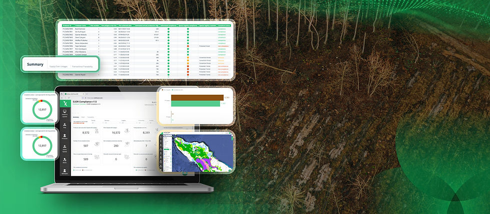
Watch a Snapshot of our EUDR Solutions

.jpg)
-
Streamline supply chain mapping and verification with integrated Koltiva ecosystem technology
-
Risk assessment with primary and secondary data
-
Land Use Tracker for EUDR deforestation maps and alert verification
-
Automated due diligence report

